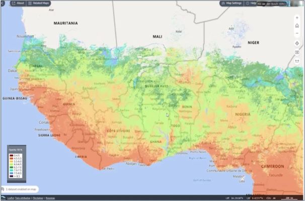
West Africa and the Sahel, a region where millions of smallholder farmers struggle with low yields and soil degradation, faces a looming threat of food insecurity. The delicate balance of these communities is further disrupted by climate change, which compounds the issue of poor soil health. However, a glimmer of hope emerges in the form of digital soil health and fertility maps, a technological innovation poised to revolutionize agriculture in the region.
These cutting-edge tools offer precise, data-driven solutions to improve soil management, boost productivity, and enhance climate resilience. By integrating vast datasets from soil samples, satellite imagery, and geospatial analysis, digital soil maps provide a comprehensive understanding of soil health across the region. This granular level of insight empowers farmers to make informed decisions, such as selecting appropriate crop varieties, optimizing planting schedules, and tailoring irrigation strategies to local conditions. Tools like AgWise, which leverage these maps, deliver localized advice directly to farmers, enabling them to mitigate climate risks and increase their yields.
Beyond climate resilience, digital soil maps contribute to environmental sustainability by minimizing the overuse of fertilizers. By identifying specific nutrient deficiencies, farmers can apply precise amounts of fertilizer, reducing environmental harm such as soil acidification and water contamination. This precision farming approach promotes sustainable land management practices, preserving soil health for future generations.
The economic impact of digital soil maps is equally significant. By adopting data-driven practices, farmers can achieve yield increases of up to 40% and profit gains of 20%. This translates into improved livelihoods for individual farmers and, on a larger scale, reduced food import costs for nations, bolstering regional food security.
The development of digital soil maps relies on advanced technologies like artificial intelligence and machine learning, which analyze complex datasets to generate detailed and accurate maps. These tools are complemented by mobile apps and digital platforms that provide user-friendly access to soil data and recommendations for farmers and extension agents. Collaborative efforts between organizations like the International Soil Reference and Information Centre (ISRIC), iSDAsoil, and the Regional Hub for Fertilizer and Soil Health for West Africa and the Sahel (the Hub) contribute to the accuracy and reach of these maps.
While the potential of digital soil maps is immense, challenges remain, ensuring high-quality, standardized data collection and sharing is crucial. Unified databases and partnerships between governments, research institutions, and the private sector are essential to fill data gaps. Additionally, investments in digital infrastructure and capacity-building programs are necessary to enable stakeholders, from policymakers to farmers, to utilize these maps effectively.
The African Union’s 10-Year Action Plan for Fertilizer and Soil Health recognizes the importance of multi-stakeholder partnerships to drive investments in soil management. The Hub’s strategy is framed by the priorities of the Fertilizer and Soil Health Roadmap 2023 and the Nairobi Declaration from the Africa Fertilizer and Soil Health Summit 2024.
“The release of improved digital soil maps is not just a technological breakthrough—it’s a testament to the collective resolve of governments, researchers, and farmers to transform agriculture in West Africa and the Sahel. Fertile soil is the foundation of food security, and these maps bring us closer to that goal,” says Bernard Vanlauwe, Deputy Director General, Research for Development at IITA and chair of the Hub consortium steering committee.
As the updated digital soil maps are set to launch in early 2025, the Regional Hub is actively working on expanding mapping efforts, enhancing data accuracy, and supporting the development and adoption of climate-smart agronomy tools like AgWise. AgWise is a freely available, open-source tool that provides data-driven, localized, and climate-specific agronomic recommendations. It combines agronomic and geospatial datasets from field trials, market analyses, and open data sources to deliver tailored advice on optimal planting times, cultivar selection, fertilizer types and quantities, and good agronomic practices. Currently supporting eight crops, including cassava, maize, rice, potato, and wheat, in key African countries, AgWise integrates soil, weather, and satellite data from sources like ISRIC to contextualize recommendations for specific growing conditions. Designed to empower smallholder farmers, the platform offers actionable insights to improve productivity and profitability, while its open-source nature enables further development by the global agricultural community.
Governments, donors, and private-sector stakeholders have a crucial role to play in realizing the full potential of digital soil maps. By investing in digital infrastructure and capacity building, implementing policies that incentivize the use of these tools, and fostering regional collaboration, they can contribute to a future where West Africa and the Sahel achieve resilient, sustainable, and inclusive agricultural growth, ensuring food security and prosperity for generations to come.
“Agricultural productivity and soil resilience in West Africa and the Sahel aren’t just about food security—they are foundational to economic stability and climate resilience,” notes Vanlauwe.
As we approach the release of the new maps, the promise of data-driven agriculture in West Africa has never been more tangible.
About the Regional Hub for Fertilizer and Soil Health for West Africa and the Sahel:
The Regional Hub is a collaborative effort initiated at the Africa Fertilizer and Soil Health Summit in Nairobi on May 8, 2024, focusing on combating soil health decline in the region. It was launched in IITA headquarters in Ibadan, Nigeria, in June 2024 and brings together key stakeholders, including the International Institute of Tropical Agriculture (IITA), OCP Africa, the African Plant Nutrition Institute (APNI), University Mohammed VI Polytechnic (UM6P), International Fertilizer Development Centre (IFDC), and the World Bank. The Hub invites partnerships with other organizations, research institutions, and private sector entities to achieve a thriving agricultural future in the region.
The impact of the Hub is magnified by the collaboration of key partners, each contributing its unique strength. The International Institute of Tropical Agriculture (IITA), the agricultural research partner with a proven track record in advancing crop production in Africa, was selected to host the Hub. OCP Africa provides tailored, sustainable fertilizer solutions to meet the specific needs of local soils and crops essential for improving soil fertility and agricultural sustainability. The African Plant Nutrition Institute (APNI) advances plant nutrition research and develops training programs, helping farmers build knowledge and implement best practices in soil health management. The International Fertilizer Development Center (IFDC) supports the Hub with its expertise in developing and disseminating effective fertilizer technologies and fostering public-private partnerships to ensure innovative solutions reach farmers.
Accelerating the Impacts of CGIAR Climate Research for Africa (AICCRA) is a key knowledge partner that offers soil information, knowledge management, agronomy recommendations, capacity development, policy support, and advocacy. Mohammed VI Polytechnic University (UM6P) drives scientific and technical advancements through soil mapping, remote sensing, and precision agriculture tools. The Economic Community of West African States (ECOWAS) plays a crucial role in aligning the Hub’s activities with regional policies and promoting best practices across member states.


